Kookaburra Crash site
Submitted: Sunday, Apr 02, 2017 at 14:59
ThreadID:
134580
Views:
8196
Replies:
8
FollowUps:
7
This Thread has been Archived
equinox
Gday,
Does anyone know where the
crash site is located?
I'd ask Dick Smith but can't find his contact details anywhere.
Planning to visit Wave
Hill where Gough poured the sand etc etc and I know it's somewhere south east from there. Haven't rung them yet - just making preliminary inquiries. Internet doesn't seem to provide any answers.
Cheers
Alan
Reply By: IvanTheTerrible - Sunday, Apr 02, 2017 at 16:28
Sunday, Apr 02, 2017 at 16:28
80
miles ESE of Wave
Hill
APPROX. 18°LAT. 132° LONG.
These were the early site descriptions
AnswerID:
609857
Reply By: cruza25 - Sunday, Apr 02, 2017 at 16:39
Sunday, Apr 02, 2017 at 16:39
Scroll down here
http://keithandersonaviator.blogspot.com.au/
And this one has the location
http://mosman1914-1918.net/project/blog/keith-anderson-memorial
Cheers
Mike
AnswerID:
609858
Follow Up By: equinox - Sunday, Apr 02, 2017 at 17:12
Sunday, Apr 02, 2017 at 17:12
Hi Thanks Mike,
That position makes it ever so slightly closer to the Stuart Highway than the Buntine Highway.
I'm hypothesising that the co-ords may only be approx due to the even minutes in Longitude however that should not be too much of a problem, especially if there are some tracks in the vicinity.
Someone (thanks someone) has sent me snail mail details for Dick Smith so have that as an option now too.
Cheers
Alan
FollowupID:
879729
Reply By: The Explorer - Sunday, Apr 02, 2017 at 17:22
Sunday, Apr 02, 2017 at 17:22
Hello
Not that relevant to question but from what I have read the plane didn't "crash" - it was a "forced landing".
Happy travels.
Cheers
Greg
| I sent one final shout after him to stick to the track, to which he replied “All right,” That was the last ever seen of Gibson - E Giles 23 April 1874 Lifetime Member
My Profile My Blog Send Message
Moderator |
AnswerID:
609861
Follow Up By: cruza25 - Sunday, Apr 02, 2017 at 20:37
Sunday, Apr 02, 2017 at 20:37
That's correct Greg
If you look at the links it describes a forced landing due to push rod failure causing a misfire
The photo shows the plane intact in
the desert .
An interesting bit of history.
Cheers
Mike
FollowupID:
879739
Reply By: Gundarooster - Monday, Apr 03, 2017 at 11:48
Monday, Apr 03, 2017 at 11:48
Guys,
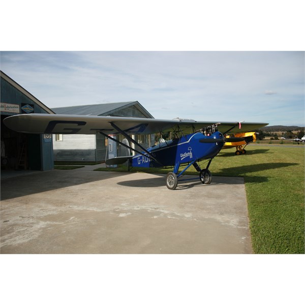
This is a photo of the replica of the aeroplane which uses some parts Dick salvaged in the early 80's.
It lives on his property near Gundaroo.

Westland Wigeon Replica of the Kookaburra
Next time I get a chance I'll ask him for the GPS co-ords of the exact location.
Gazza
AnswerID:
609880
Follow Up By: equinox - Monday, Apr 03, 2017 at 19:20
Monday, Apr 03, 2017 at 19:20
Wow - imagine flying across Australia in that thing.
Thanks Gazza
FollowupID:
879777
Follow Up By: Gundarooster - Tuesday, Apr 04, 2017 at 14:34
Tuesday, Apr 04, 2017 at 14:34
I understand there are only two left in the world on the civil register, this one and one at the Air Museum in Wangaratta Vic? Last time I heard the one at Wang had been continuously registered since being built and was still airworthy.
Gazza
FollowupID:
879796
Reply By: Member - Darwin Dave - Wednesday, Apr 05, 2017 at 11:35
Wednesday, Apr 05, 2017 at 11:35
Hi Alan,
Can't help you with your first question but when I worked in the Alice in the early 70's I came across an old fellow that told me a story of a failed trip into the Tanami to retrieve an old aeroplane.
They left from somewhere around
Elliott. They had endless punctures and had to drain the radiator water each night and heat it in the morning to get the vehicle going. Always wondered why they would use a British 2 wheel drive light truck when there were plenty of 4 x 4 International and ex World War II trucks around. Now I realise he was talking 30-40 years back and I think the plane would have been the Kooaburra.
From the the late 70's through to the late 90's I hauled fuel out of
Darwin to some pretty remote stations and out stations. One of interest to you would be Wave
Hill Station. I would drop off 2 tankers, leave 2 compartments of diesel on my lead trailer and go south east to Cattle Creek, pump 1 out and use the other for ballast to get back. Fair bit of sand and dry season only.
Talking to one of the ringers and he told me they had bores a fair way south from Cattle Creek and one south east called Kookaburra.
This might put you within striking distance of your target. Remember from where the plane landed to where it's remains were found may be quite a distance.
Regards,
Dave
AnswerID:
609937
Follow Up By: equinox - Wednesday, Apr 05, 2017 at 21:09
Wednesday, Apr 05, 2017 at 21:09
Hi Dave,
Thanks for your reply.
It sounds like the old fellow was onto the Kookaburra.
Looking at the map there is a
bore called the Kookaburra out to the south east.
It would be a good place to head out for a look.
Wave
Hill would be a good one to visit, lots of history.
Cheers
Alan
FollowupID:
879843
Reply By: Tony I - Wednesday, Apr 12, 2017 at 16:08
Wednesday, Apr 12, 2017 at 16:08
Gday Alan,
That will be another interesting trip for you. Not sure if you've seen it but Les Hiddins did a 30min doco on the Kookaburra story in his series "Stories of Survival" which is on Youtube. I found it pretty interesting.
Cheers
Tony
AnswerID:
610166
Follow Up By: equinox - Wednesday, Apr 12, 2017 at 20:45
Wednesday, Apr 12, 2017 at 20:45
Gday Tony,
Yes I have seen the Les Hiddins doco, very interesting. He had a good way of telling a story
Look forward to having a look.
Cheers
Alan
FollowupID:
880096
Reply By: Member - Graeme W (NSW) - Saturday, Apr 22, 2017 at 12:25
Saturday, Apr 22, 2017 at 12:25
Hi Alan,
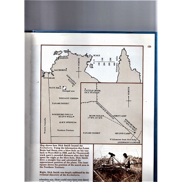
This is a scanned image from the book Kookaburra by Pedr Davis and Dick Smith (Lansdowne Books 1980).

Kookaburra Map
From the text:
'Draw a line from the old Wave
Hill station over the blow-hole and straight out. The truck's odometer had shown 23
miles and if we scale this off along the line, it will show us where the Kookaburra is. In other words, we should combine Lester Brain's directions with the truck odometer distance readings. we drew the line 23
miles out and allowed a mile for probable wheel slip"
After the wreck was discovered:
It was exactly as Lester Brain had said, in line with Wave
hill station and the blow-hole and 21.5
miles from the
blow hole."
Lester Brain was
the pilot that originally found the Kookaburra and was still alive when Dick Smith started his search.
Blow hole 17 deg 48'S 131 deg 42'E
Kookaburra 17 deg 56'S 131 deg 58' E

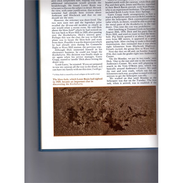
Aerial photo of blow hole
Graeme
AnswerID:
610436
Follow Up By: equinox - Saturday, Apr 22, 2017 at 15:16
Saturday, Apr 22, 2017 at 15:16
Hi Graeme,
Thank you very much for this information.
I ordered the book almost two weeks ago on Ebay and it hasn't arrived yet.
I'm hoping to be in the area in the area in about 7 or 8 weeks, I will let you know how I go.
Cheers
Alan
FollowupID:
880376
Reply By: ckl80series - Thursday, May 18, 2017 at 21:39
Thursday, May 18, 2017 at 21:39
Hi I went to the
crash site a few yrs ago I drove down from Stuart
bore on wave
hill stations southern fence. First I drove over to the sink hole mentioned by dick smith then from there headed south east to the
crash site. There is no road to the.
crash site.you must drive threw quite over grown country and some areas that have been burn out and many standing dead wood which can potentially tear your tyres to bits. The
crash site is about 3 kms or so north of Anderson's corner.
AnswerID:
611195