Iron Knob S.A. to My Ive Station
Submitted: Thursday, May 04, 2017 at 17:40
ThreadID:
134791
Views:
4392
Replies:
10
FollowUps:
6
This Thread has been Archived
Robert D1 (SA)
G'Day
Anyone driven this road recently..??
Wondering what sort of timeframe to allow.
Google says 5:15 to drive the 126 Km. That works out around 25kph average speed....seems very slow to me.
We managed similar speeds recently in the
Vic High Country..!! The corugations must be awful.. ..
Cheers
Rob
Reply By: Member - Don & Kathie M (TAS) - Thursday, May 04, 2017 at 20:08
Thursday, May 04, 2017 at 20:08
This time last year it took us just under 2 hours.
AnswerID:
610784
Reply By: Member - nick b - Thursday, May 04, 2017 at 20:21
Thursday, May 04, 2017 at 20:21
I think the 5 hrs is via the
wudinna bakery ...... MMM very tasty :-)))
AnswerID:
610785
Follow Up By: Member - Charlie M (SA) - Thursday, May 04, 2017 at 20:25
Thursday, May 04, 2017 at 20:25
Darn good
bakery as
well, going west have to stop there, going to
Adelaide, have to stop at Kiplings in
Port Wakefield as
well. lol.
Sorry for off track.
FollowupID:
880787
Follow Up By: Member - nick b - Friday, May 05, 2017 at 07:28
Friday, May 05, 2017 at 07:28
P.S don't underestimate the slipperiness of these roads when wet .
FollowupID:
880797
Reply By: Les - PK Ranger - Thursday, May 04, 2017 at 20:52
Thursday, May 04, 2017 at 20:52
Google maps times for off the blacktop are a little over the top most times :)
If not in a hurry, do yourself a favour, go a bit further to
Kimba, up to Buckleboo Hall, then west and do a drive down Buckleboo Stock Route, Corrobinnie
Rock, through and up to Mt Ive should be possible via just north of
Wudinna (where you exit Buckleboo Stock Route), and up via Mt Sturt / Sturts Tk which is where the
Gawler Ranges NP boundary is in the south.
Great camping at
Pildappa Rock on the way up too.
The springs on top of
Pildappa Rock are spring fed, permanent.
AnswerID:
610787
Follow Up By: Robert D1 (SA) - Thursday, May 04, 2017 at 21:29
Thursday, May 04, 2017 at 21:29
Was originally planning to
camp &
Pildappa Rock, then continue on to
Maralinga - but the
Maralinga side of things didn't work out.
So now its Mt Ive Station. Thanks for the tips - will bear them in mind.
FollowupID:
880791
Follow Up By: Sigmund - Friday, May 05, 2017 at 08:07
Friday, May 05, 2017 at 08:07
Can recommend a look at
Lake Gairdner, esp at dawn or dusk. Sensational.
Can be accessed from Mt Ive's property - ask for a key.
FollowupID:
880799
Follow Up By: Kevin S - Life Member (QLD) - Sunday, May 07, 2017 at 17:34
Sunday, May 07, 2017 at 17:34
The key will cost you $60 as I recall. And that is just to hire it. You have to give it back. Other dives on the station were free last year.
Cheers,
Kevin
FollowupID:
880876
Reply By: Motherhen - Thursday, May 04, 2017 at 22:51
Thursday, May 04, 2017 at 22:51
I don't recall our times - too many years ago but it was normal speed for a maintained unsealed road at the time. It was closed a few days or so ago following rain, now open with 'drive to the conditions'.
AnswerID:
610790
Reply By: Outback Epicurean - Friday, May 05, 2017 at 09:14
Friday, May 05, 2017 at 09:14
Went through there last September. Easy drive if dry. Couple of hours. Mt Ive great spot to
camp with good sightseeing and drives.
Gawler ranges has many great camping spots so plan at least 3-4 days to look around
AnswerID:
610796
Reply By: phantom - Friday, May 05, 2017 at 11:25
Friday, May 05, 2017 at 11:25
Hi Rob,
We did the drive late Feb for Speed Week. Took 1.5 hours averaging 80kph towing a camper. Some corrugations and bull dust but generally pretty good. Definitely not a 5 hour trip....
AnswerID:
610809
Follow Up By: Robert D1 (SA) - Friday, May 05, 2017 at 15:59
Friday, May 05, 2017 at 15:59
Thanks - that's more what I expected.
1 & a half to 2 hours..!!
But - always good to ask before heading out.
FollowupID:
880809
Reply By: ExplorOz Team - Michelle - Friday, May 05, 2017 at 15:23
Friday, May 05, 2017 at 15:23
According to either the ExplorOz
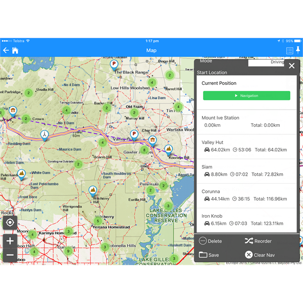
Gawler Ranges Trek Note that section will take 1 hr 43. You can create this section as a private trek in our app
ExplorOz Traveller by bringing up the
Gawler Ranges Trek then deleting the points that you don't need - that's how I got the result. This screen shot shows the result but using the latest update of the app (soon to be released) so the layout of the nav screen has a little more detail including driving time.

ExplorOz Traveller navigation screen shot of a private trek
NOTE: one of the big features of the ExplorOz Trek notes (whether you use them online on our site, or offline in our app, is that we have the recorded plot files for true driving times - does not rely on Google driving directions so is accurate.
AnswerID:
610818
Reply By: Old 55 - Saturday, May 06, 2017 at 13:22
Saturday, May 06, 2017 at 13:22
Drove the road a month ago to Mt Ive from
Wirrulla with standard road Caravan and took us about 3 hours. Lots of bulldust but road was good. Did the
Gawler Ranges next couple of days then drove
Mount Ive to
Iron Knob and was about 2 hours and road was in good condition {
grader was working sections of it} except the last stretch from Nonning into
Iron Knob.
Grader should have finished that section by now.
Great country but would be different if it rained.
AnswerID:
610846
Reply By: Member - KenD - Monday, May 08, 2017 at 02:08
Monday, May 08, 2017 at 02:08
Hey Rob
Did it 2 weeks ago. 2 easy hours and the road in good nick. It had dried after recent rains when it had been closed for a short time. Pull up at the phone box and drop a couple of bucks in the flying doctor tin.
Highly recommend Mt Ive. Good people and some good drives.
Lake Gairdner visit was
well worth the cost and the drive. A scrambly drive up to
the summit of Mt Ive gives a wonderful 360 deg vista.
Enjoy!
KenD
AnswerID:
610902
Reply By: Stone Stomper - Tuesday, May 09, 2017 at 07:13
Tuesday, May 09, 2017 at 07:13
We did it in the school holidays with our parents and took around 2.5 hours towing in dry weather.

SA

SA1
AnswerID:
610948