Mitchell River Crossing at Dunbar
Submitted: Monday, Apr 29, 2013 at 20:49
ThreadID:
101928
Views:
7645
Replies:
9
FollowUps:
9
This Thread has been Archived
Member - matsta
Hi Everyone, we are planning on crossing from Musgrave to Nomanton through Dunbar in late July. Can anyone advise if the crossing at the
Mitchell River is doable with camper trailers or even doable at all??
Reply By: Member - eighty matey - Monday, Apr 29, 2013 at 23:21
Monday, Apr 29, 2013 at 23:21
When we were there in 2010, the Toyota from Koolatah (the property on the north side of the
Mitchell) was stuck in the middle of the river waiting for the
grader.
It's not far across the main channel but it is about 1200 deep and soft sand.
If you need the station
grader to pull you out it will cost $1000, even if it comes down to pull out their vehicle at the same time.
Another option is to head west to Kowanyama, then on to Pormpuraaw. I have only see pictures of this crossing but in 2010 it was wider but more doable than the first option.
The easiest way to go is to continue east to Gamboola and cross there. They have a concrete causeway, then you follow the station tracks (more like decent dirt roads) through King
Junction, Killarney and Dixie. You will still hit the PDR at the same point near Dixie Outstation and then on to Musgrave. It's an interesting drive and you won't get much traffic, if any. Plenty of room for bush camps. We got lost going through a deserted gold
mine for a while.
My preferred option would be through Kowanyama but it would be advisable to
check with Kowanyama and Pormpuraaw Community Offices first,, or go for a drive.
Here's some photos;
Gate to Mitchell River, Koolatah Station, NQ
Koolatah Station Cruiser ute stuck in the Mitchell River
Mercedes crossing the Mitchell, via Kowanyama, NQ
I apologise if the third picture doesn't work but click on it and see what happens. It's a good picture if you get to see it.
Hoo roo,
Steve
AnswerID:
510007
Follow Up By: Rockape - Tuesday, Apr 30, 2013 at 16:05
Tuesday, Apr 30, 2013 at 16:05
Steve,
I like the 3 pointed star coming out of the river. Nice photo
FollowupID:
788092
Follow Up By: Member - eighty matey - Tuesday, Apr 30, 2013 at 18:34
Tuesday, Apr 30, 2013 at 18:34
Yeah, it's impressive.
The photo is from a report that was in the 4wd Action
Forum in 2010 by Bushie. I'll try and find it and put up a link because it's a really
well written trip report.
Steve
FollowupID:
788105
Reply By: gbc - Tuesday, Apr 30, 2013 at 06:13
Tuesday, Apr 30, 2013 at 06:13
Strathleven Rd through Fairview to
Laura is a more reliable crossing also.
AnswerID:
510010
Follow Up By: Lyn W3 - Tuesday, Apr 30, 2013 at 07:55
Tuesday, Apr 30, 2013 at 07:55
GBC,
Where exactly do you mean, are you crossing at Gamboola and going north past Strathleven and Kings
Junction and turning right north of
Pinnacles. we go that way but go up through New Dixie and join the PDR just south of Musgrave.
FollowupID:
788062
Follow Up By: gbc - Tuesday, Apr 30, 2013 at 10:34
Tuesday, Apr 30, 2013 at 10:34
Sounds about right. I think it was the
Kimba Rd we used which comes out about 5 km North of
Laura, or you could turn North again earlier if you were trying to hit Musgrave. Musgrave was under water when we last tried so
Laura was the only option. Pretty wet through there at the moment too.
FollowupID:
788071
Follow Up By: gbc - Tuesday, Apr 30, 2013 at 14:31
Tuesday, Apr 30, 2013 at 14:31
Just checked. The crossing we used was another 40 km back from gamboola towards wrotham park. Different tracks but they link further up if I remember correctly.
FollowupID:
788084
Follow Up By: Lyn W3 - Tuesday, Apr 30, 2013 at 15:52
Tuesday, Apr 30, 2013 at 15:52
Looks like you took the track through Palmerville Stn.
FollowupID:
788091
Follow Up By: Member - eighty matey - Tuesday, Apr 30, 2013 at 18:36
Tuesday, Apr 30, 2013 at 18:36
You can take the crossing at Gamboola and there's a turn off to
Laura about a third of the way up.
Steve
FollowupID:
788106
Reply By: Life Member TourBoy, Bundaberg - Tuesday, Apr 30, 2013 at 06:40
Tuesday, Apr 30, 2013 at 06:40
We did it in 2007 with both my 105 cruiser and my FIL's prado both towing campers. He got stuck 3 times and I had to recover him. Ensure you let your tyres right down or don't bother and also that you can extract yourself if need be. Don't forget there are big lizards around there.
AnswerID:
510013
Follow Up By: Lyn W3 - Tuesday, Apr 30, 2013 at 07:47
Tuesday, Apr 30, 2013 at 07:47
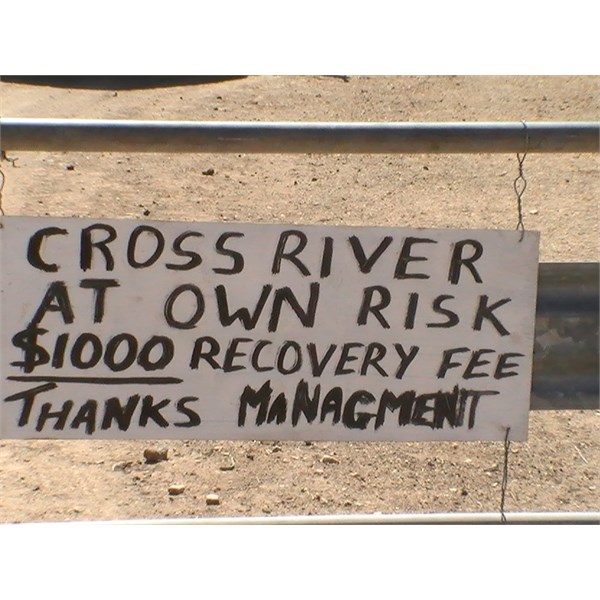
Didn't I read somewhere that they were working on the crossing at Dunbar and it was supposed to be finished this year.
We looked at the
gate..........saw the sign and crossed at Gamboola.
Just remember its a fair way from
Normanton to the next fuel at Musgrave.
FollowupID:
788060
Reply By: Lyn W3 - Tuesday, Apr 30, 2013 at 07:59
Tuesday, Apr 30, 2013 at 07:59
If you are coming from the north it is a LONG WAY to go back if you get to the river and can't get across.
At least going north you can drive to the
gate,
check it out and if too high go via Gamboola.
AnswerID:
510017
Reply By: ctaplin - Tuesday, Apr 30, 2013 at 10:10
Tuesday, Apr 30, 2013 at 10:10
It now has a concrete causeway across and is do able in a 2wd!
AnswerID:
510028
Reply By: ctaplin - Tuesday, Apr 30, 2013 at 10:12
Reply By: MATSTA - Tuesday, Apr 30, 2013 at 13:23
Tuesday, Apr 30, 2013 at 13:23
Thanks everyone for your replies. GREAT pics!! Great to here there is a causeway there now. I guess it's a case of watch the weather and water levels.
AnswerID:
510040
Follow Up By: Lyn W3 - Tuesday, Apr 30, 2013 at 15:50
Tuesday, Apr 30, 2013 at 15:50
I would
check to see if you can infact get all the way through, it would need to be pretty dry.
FollowupID:
788090
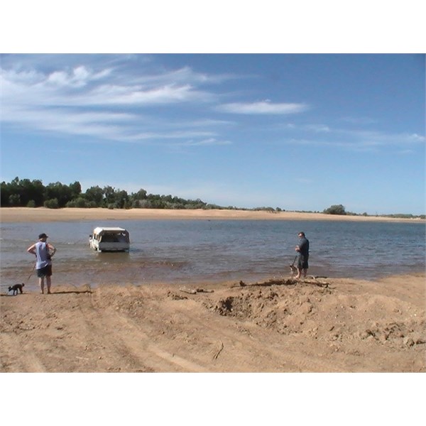
Reply By: Lyn W3 - Tuesday, Apr 30, 2013 at 16:04
Tuesday, Apr 30, 2013 at 16:04
This is the crossing at Gamboola we are all talking about
AnswerID:
510046
Reply By: lindsay - Tuesday, Apr 30, 2013 at 19:58
Tuesday, Apr 30, 2013 at 19:58
Was at the Dunbar crossing last year. It was a leggo crossing at that time and the sand had been scoured out from under the structure and it was not knownif it was structurally secure. After seeing the same type just north on
Richmond and how insecure it looked after being half washed away we decided not to tempt it. Also the road north over the river was washed out to the north. We then went down stream to the Alice Mitchel nat park to cross there, however a large amount of bank had been washed out and there was a vehicle stuck there. So with camper trailers we headed back to Gambolia and the photo earlier looks a hell of a lot different from what it was last July.
These bridges may
well be repaired by now but you can't trust anyone as we were told by a roads foreman that the Alice
Mitchell crossing was ok and that road trains used it this was wrong.
enjoy your trip.
AnswerID:
510058