|
12th October 2018 Hi ExplorOz Reader,
There has been so much activity at ExplorOz headquarters, as well as from ExplorOz audiences and app users that we thought it was time for a newsletter update to wrap it all up.
NEW LAYOUT IN PLACES
We've recently modified the layout of how you view/find extra information on Places pages. Previously, Nearby Places were found only if you clicked the Description tab so it was somewhat less obvious. We've now put Nearby Places in their own Tab so it is more obvious for you to click this to see what's nearby.
We've also added a new Tab to each Place listing on the website to help you identify local Wildflowers. Currently, this feature is only available on the website but we're looking at bringing this to app users ( ExplorOz Traveller) soon.
NEW TOOLS IN WILDFLOWERS
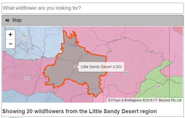
We've recently added a very useful tool to the Wildflowers section of the website. Now if you open Wildflowers you'll see a tab with the heading MAP. If you click this, you will see a map that has clickable regions - these are the IBRA regions (bioregions) for Australia. All wildflowers in our system are categorised into their appropriate region. If you click any of the regions from the map, you see the name of the region and the page will display a list of all Wildflower listings from our database collection for that bioregion (click each one to open full page details). Photos, Family Name, Genus, Species, and main flower colour is given for each wildflower listing along with supporting references and other information where relevant. Please note that anyone is welcome to submit new listings, or post comments/reviews. 
You'll also find a new tab on the main Wildflower page that says "My Current Position".
If your device has a GPS and location services turned on (eg. phone, tablet or iPad), then you can use this tab to quickly view a list of wildflowers in your region. This is particularly useful if you're travelling and want an easy way to identify unknown flowering species you happen to find. NOTE: our database does not contain weeds or introduced species so if you're finding it difficult to identify a flower, chances are its not an endemic wildflower.
EXPLOROZ TREKSExplorOz Trek, User Trek, Private Trek - do these terms confuse you? Read this section for an explanation.
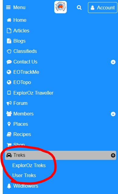
The image below shows the ExplorOz website menu index - this is what you see if you click the word "Menu" at the top left of our website. The index shows all the parts of the site arrangement in alphabetical order so if you scroll down to T for Treks and click on it, you'll see it opens up 2 more headings - ExplorOz Treks, and User Treks. As shown in the image below:-

The ExplorOz Treks refers to the itineraries that have been researched and verified by the ExplorOz Team. These Treks are documented in their entirety on the website and are free to view. There are over 180 ExplorOz Treks, covering every state of Australia including the iconic 4WD destinations such as CSR, Cape York, Simpson, Gibb River Rd, etc and the popular touring routes such as Matilda Way, Savannah Way, Outback Way, and historic routes such as those built by Len Beadell, as well as tracks in National Parks like Kakadu, Mungo, D'Entreacasteau, and many more.
These Treks contain an extensive amount of text to describe the route, the local history and ecology, and everything you might need to know to undertake a trip along its path including permit information, best time to visit, fuel requirements etc. Of most significance is the driving notes and mapped route that you can view on the webpage.
5 NEW TREK UPDATES
As the provider of these Treks, we actively keep on top of the content to ensure they are always up-to-date with accurate information. In the last few weeks, we've made extensive updates to 5 of the ExplorOz Trek Notes, being: When you view the Trek Notes on the website, you can read a statement that describes what to do if you'd like to save this information for use offline. The ideal solution is to download the ExplorOz Traveller App,
which will contain all the information you see online, plus give the
ability to guide you along the route with driving time and driving
distances all displayed in a very easy-to-use format. HOW CAN APP USERS GET THESE NEW TREK UPDATES?Anyone that already has the Traveller app already has the Treks database so you've got them all offline on your device already BUT unless you have recently pressed UPDATE in the Data Manager you won't automatically get the updates. To check, simply open the app and go into the Data Manager. Check the date showing for Places & Treks (if it's older than 11th September then press UPDATE). This will overwrite your offline Places & Treks content in the app with the latest version - free of course! USER TREKSAs you'll see in the site menu, there is another section in the Trek Notes menu, called User Treks. These are a collection of user-submitted GPS data files and descriptions. These are not checked or validated by the ExplorOz Team. There are over 4700 of these User Treks, however so there is a lot of great data here, so we're sure you want to know as much as you can about them.
User Treks are created by site users. These offer completely different information to what is offered by the ExplorOz Treks however, because our system allows very basic GPS data to be submitted without any supporting trip planning information, so they do not have any planning notes, driving notes, etc. There are tools to enable authors to add photos and add more details but most often people usually submit just the GPS track files.
A User Trek can be submitted to the ExplorOz site in any of the following ways: - created on the user's computer in a mapping program by manually clicking points on a map to draw a route saved in the GPX file format, or the PLT format from OziExplorer software, or in the TCX format from Garmin software. So they have this file on their computer and go to the User Trek section of our site and click Upload User Trek which sends up the file from their computer to our site. Some people create such files for the purpose of planning and have not actually driven the route so accuracy of User Treks are variable depending on who and how the file has been made. Our system will display an accuracy statement to give you a guide - this is shown as a Number of Points. The higher the number of points across a given distance the greater the accuracy. This is because the route line that is drawn by the system is simply connecting the dots between points.
- created by capturing GPS position data during a journey using a navigation software program. The Description panel in the User Trek will confirm what device and/or app or software was used to create the file.
- "Created by ExplorOz Traveller" - means the User Trek was created using the Positions Manager in the ExplorOz Traveller app by selecting a date range to build a route of all position data collected by the device (includes snail trail and track logging to ensure highest accuracy possible).
- "Track Log from EOTraveller" - means a Member has enabled track logging in the ExplorOz Traveller app and has pressed the save button on their active tracking log (either in-app or on their member tracking page on the website). This automatically creates a User Trek.
- "Track Log from EOTrackMe" - means a Member has used the EOTrackMe app for track logging and has pressed saved from their member tracking page. This automatically creates a User Trek.
- "Track Log from SPOT device" - means a Member has registered a SPOT device to the EOTrackMe service and has pressed saved from their member tracking page. This automatically creates a User Trek.
As you can see if you look through the list of New User Treks on the website, the majority are now recorded using the ExplorOz Traveller app, or EOTrackMe.
If you find a User Trek and you press Download to Device (this is a Member-only feature), then you have the choice of file format - GPX , CSV. GeoRSS, Hema Navigator, OziExplorer. This means you can only use the User Trek in a device/program that can read this file format. NOTE: Other people's User Treks cannot be imported into our app ExplorOz Traveller, but you own User Treks will be visible in the app.
Hopefully you've found this explanation helpful. If not and you want to discuss it further, please pop your question into the Forum and one of our enthusiasts will be only too happy to provide more information.
WHERE TO GET OUR APP
If you're ready to get our app "ExplorOz Traveller", simply use your device (Android phone, tablet, iPad, iPhone, or Windows 10 device) and click the relevant store below to visit the app page in-store. After payment to the store of AU$59.99 and a 12MB download you will have the app on your device with immediate access to our 3 online map sources for the whole of Australia (EOTopo, Streets & Paths, and Satellite). If you intend to use the app without Wifi or 3/4G internet then you will also need to purchase the ExplorOz Traveller Premium Offline Map license for $49.99 - you can buy this direct from us here.
For Android devices go to the Playstore

For iPads & iPhones go to the App Store

For Windows 10 devices go to the Windows Store

ExplorOz ® is owned and managed by I.T. Beyond Pty Ltd.
Contact Us | Join | Advertise
|