Old Natmap (
Submitted: Friday, Jul 29, 2022 at 16:07
ThreadID:
144264
Views:
5862
Replies:
2
FollowUps:
15
This Thread has been Archived
Zippo
Gazz's thread reminded me of a trip I did 50 years back, during which we had several of the above series.
We camped at a spot shown as "Blackstone Mining
Camp (abandoned)" at a
junction, on the north side of the
Warburton-Blackstone-?Mulga Park road. Unfortunately the modern incarnations of those sheets showing the section of road - being SG5206 Scott and SG5210 Cooper - no longer have that rerefence.
Does anyone happen to have those oldies in their archives showing that location?
Reply By: equinox - Friday, Jul 29, 2022 at 16:40
Friday, Jul 29, 2022 at 16:40
Hi Zippo,
I have looked at 3 editions of Natmap from first to last and middle. Can't find it. There is a Blackstone Mining Centre on the 3 editions I looked at, 8 or 9 kms east of Blackstone.
Cheers
Alan
AnswerID:
641317
Follow Up By: Frank P (NSW) - Friday, Jul 29, 2022 at 17:31
Friday, Jul 29, 2022 at 17:31
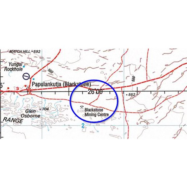
Could be at the northern most of the two intersections below, but no specific mention. Could be at either of the other two intersections outside the circle as
well??

Blackstone mining camp
FollowupID:
920380
Follow Up By: equinox - Friday, Jul 29, 2022 at 17:38
Friday, Jul 29, 2022 at 17:38
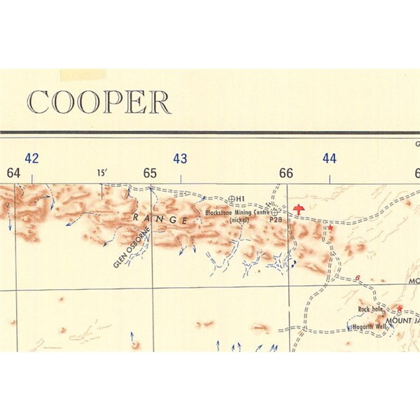
Excerpt from Natmap 1965

Cooper map sheet
FollowupID:
920382
Follow Up By: Frank P (NSW) - Friday, Jul 29, 2022 at 17:40
Friday, Jul 29, 2022 at 17:40
Do you have the next chart north, Equinox?
FollowupID:
920383
Follow Up By: equinox - Friday, Jul 29, 2022 at 17:49
Friday, Jul 29, 2022 at 17:49

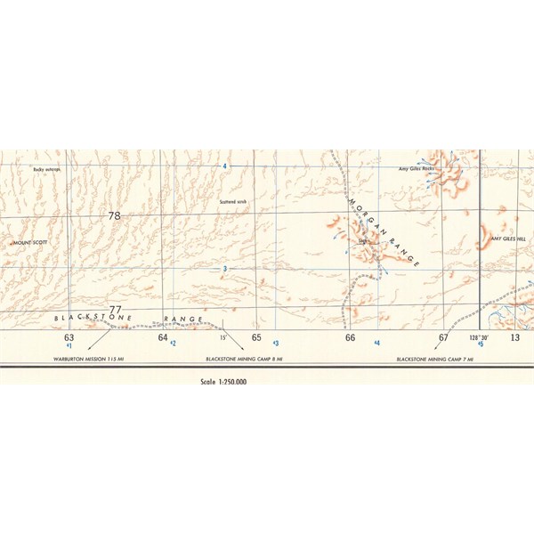
Scott map, which is above Cooper
FollowupID:
920385
Follow Up By: equinox - Friday, Jul 29, 2022 at 18:00
Friday, Jul 29, 2022 at 18:00
Do you have a nautical background Frank? :-)
FollowupID:
920388
Follow Up By: Frank P (NSW) - Friday, Jul 29, 2022 at 19:09
Friday, Jul 29, 2022 at 19:09
You've lost me there mate LOL.
But no, not nautical. Aviation.
FollowupID:
920393
Follow Up By: equinox - Friday, Jul 29, 2022 at 19:17
Friday, Jul 29, 2022 at 19:17
OK, that makes sense too.
It was the "chart" reference.
FollowupID:
920394
Follow Up By: Frank P (NSW) - Friday, Jul 29, 2022 at 19:31
Friday, Jul 29, 2022 at 19:31
Ah, yes, that crossed my mind, but crossing is all it did. It didn't stop, LOL.
A cartographer might have said " sheet" but I'm not one of those.
I was hoping the Mulga Park road might have been on the Scott sheet/chart. Maybe it wasn't there when the sheet was compiled?
Cheers
FollowupID:
920395
Follow Up By: Zippo - Saturday, Jul 30, 2022 at 19:29
Saturday, Jul 30, 2022 at 19:29
Frank, the northern of the two junctions you circled is on the road that didn't exist back then (according to the map segments Alan posted). The most likely candidate for our southerly approach would be the track just west of the 66
grid on Scott, which meets the E-W road on Cooper but with odd geometry cf the two you circled. The (abandoned)
camp site didn't align with anything visible in the way of mining activity - it was just another spot in the middle of nowhere which we picked because it was cleared ground.
Both the two junctions you circled fit my recollection of the road geometry better than the old Cooper
junction adjacent the mining centre.
FollowupID:
920410
Reply By: Member BarryG - Saturday, Jul 30, 2022 at 12:37
Saturday, Jul 30, 2022 at 12:37
Hi Zippo,
You may have this already but I just found it via Google.
It gives pretty exact directions to the
Camp.
Trek notes
Good luck,
Barry
AnswerID:
641323
Follow Up By: gke - Saturday, Jul 30, 2022 at 12:55
Saturday, Jul 30, 2022 at 12:55
Love the term sumpbashers.
Graham
FollowupID:
920402
Follow Up By: Zippo - Saturday, Jul 30, 2022 at 19:29
Saturday, Jul 30, 2022 at 19:29
Barry, that 133.9 is obviously the one. Fascinated about the source of that info, and the year their trip was undertaken. It's also going to cause me to ask myself whether we saw that reference on the area 1,000,000 map.
The "trick" now of course is to relate that to the mapped junctions in the sheets we are looking at.
FollowupID:
920411
Follow Up By: Member BarryG - Saturday, Jul 30, 2022 at 19:53
Saturday, Jul 30, 2022 at 19:53
Zippo,
With a bit more digging, I have the page that links to the one I posted. It appears that the trek notes relate to travel undertaken in the 1970s. NatMap says not to rely on these notes as the tracks have changed. The link is "MG2". Australia changed to kilometres in 1974, so these notes must pre-date that.
70s Trek Notes
This page comes from this one here
Diverse map notes
Cheers,
Barry
FollowupID:
920412
Follow Up By: Bazooka - Monday, Aug 01, 2022 at 11:51
Monday, Aug 01, 2022 at 11:51
Depends on the area but often geological maps will have better/more up-to-date topo info on them , esp where mining-related activities or mineral-prospective areas are concerned. Something to consider if you're looking for another source. Don't expect topo features like road names to be prominent though.
FollowupID:
920441
Follow Up By: Ron N - Friday, Aug 05, 2022 at 22:24
Friday, Aug 05, 2022 at 22:24
I like the "all two wheel drive" note! Nowadays, nearly any unsealed surface that is only occasionally graded, is clearly marked, "4WD ONLY!" LOL
That was obviously the days when a bog-standard Holden ute was regarded as being good enough for bush roads and tracks.
Cheers, Ron.
FollowupID:
920506
Follow Up By: Zippo - Saturday, Aug 06, 2022 at 09:05
Saturday, Aug 06, 2022 at 09:05
Ron, my vehicle back in '72 out there was definitely 2WD. Don't have a
pic to hand (as I'm on the road atm) but it was a Fiat 125
sedan, replete with four spare wheels, second fuel tank AND an Engel MRFT514 which I have with us today.
4WD ONLY? Phooey!
FollowupID:
920509