Saturday, Mar 27, 2021 at 21:16
"Eg what is 125M, 2K, 108K all mean? Is that 125 Meters, 2Km etc?
Also, what is the best scale of off line raster and vector maps?
Lastly will it do turn by turn navigation offline with the vector maps?"
Tony,
In Michelle's absence, I'll try to help you out. As a beta tester I am a bit familiar with the app - I presume you're asking about using
EOTopo within the Traveller app..
In answer to your the first line of your query, in simple terms it just means you can zoom out so all of Australia fits into your screen with a low level of detail. Then as you zoom in you get more and more detail. It's like having all maps between maybe 1:100M and 1:2000 or so.
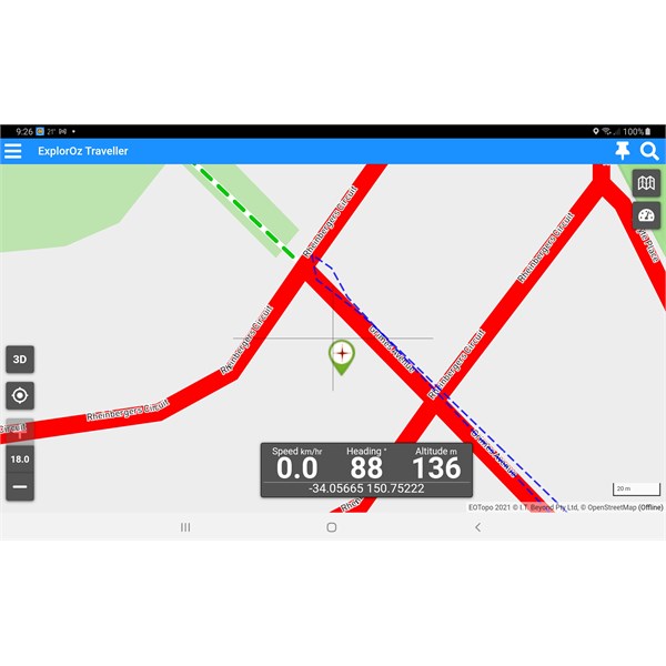
To give you an idea of the level of detail you can get, here's a screenshot of
EOTopo 2021, the all-of Australia map, at max zoom, zoom level 18. On Grimes Ave between the two legs of Rheinburgers Cct there are only three suburban houses. It lacks only house numbers. If you cannot find a destination at that level of detail,
well, perhaps it's not there, LOL.

Zoom 18
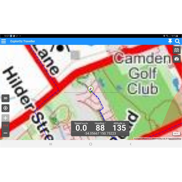
Here's the same screen at
EOTopo 2019's max zoom level of 15:

EOTopo 2019
Quite a difference, eh?
If you want house numbers you can switch to the on-line Streets and Paths map - very good for navigating around an unfamiliar town or city.
As I said, at the opposite end of the scale you can zoom out and have all of Australia on the screen - zoom level 0.9, perhaps for very small screen phones, and you can choose any level in between with 0.1 steps or pinch zoom in gross steps as fast as you like.
Your question about what is the best scale:
You don't need to know that. Just zoom until you get the detail or coverage you want on your device's screen. The actual scale is irrelevant, unless you just want to know the number. As you zoom, the scale bar on the screen expands and contracts and changes units with your zoom, as you'd expect.
Lastly about turn by turn:
If you plan your trip to remote areas when in internet coverage the turn by turn instructions are stored in your device and will talk to you at all times, even off line and with the vector maps.
If on-line you can search for an address and navigate to that.
If you are in coverage and deviate from your stored route, the app will re-route and give you new turn by turn instructions. I have tested this on multiple occasions and it works perfectly.
If, when you're off-line you deviate from the stored route, it will not update routing (ie, turn by turn) instructions. This is because the routing engine does not live in the app, it lives in the cloud, ie on line. If you return to your planned or stored route, the stored instructions will resume from the point you return to the stored route.
One thing to note for Traveller and all navigators:
The routing engines used by the various turn by turn apps can give differing results. Sometimes the way
home differs from the way to. If you run two turn by turn navigators side by side, eg the one in the car and Traveller or any other turn by turn nav program, you may get differing results. Depending on your point of view, one will be more correct and the other less so. A bit of situational awareness, rather than blind obedience of any app helps. The big advantage with Traveller's vector maps (on and off line) is you can get a hugely detailed, down to street level, map. So if a route appears weird you can zoom in and figure out your own best route.
In mobile coverage in Traveller you can select the on-line streets and paths map which gives detail down to building numbers in many
places, especially metropolitan, as
well as
walking tracks, etc.
Hope this helps
FollowupID:
913440