Definition of "gazetted roads" ?
Submitted: Saturday, Jul 14, 2018 at 01:27
ThreadID:
136981
Views:
23422
Replies:
9
FollowUps:
13
This Thread has been Archived
Candace S.
I'm trying to sort out the term "gazetted roads." Is there a generally accepted or even "legal" definition for this term?
The reason for my quest is due to one of our favorite topics here: Hire company Terms and Conditions. :)
In the Apollo T&C, one can find the following statement:
"Four Wheel Drive Vehicles...may be driven...on unsealed roads on the condition that the roads driven on have been gazetted. Gazetted roads are roads that appear on official road maps and street directories"
Partly out of curiosity to see what response I would get, I emailed this inquiry:
"I'm interested in driving on remote roads such as the
Gary Junction road; the Sandy Blight Road; the Connie Sue Highway; and the
Anne Beadell Highway. Are your vehicles allowed on those roads? Those roads appear on Hema, etc. maps, but are they considered to be "gazetted"? "
Here's the response I got:
"You would be welcome to use either google maps, or any recent government issued map... The bellow [sic] listed roads would be ok to travel on with our vehicle, however a permission would be required on pick up."
So, Google Maps is a definitive source?! What do you all make of this?
BTW, while the AB, CS, and Sandy Blight all appear on Google Maps, the
Gary Junction Road does not.
Reply By: Michael H9 - Saturday, Jul 14, 2018 at 07:55
Saturday, Jul 14, 2018 at 07:55
It seems you really have to find out what are regarded as the "official road maps and street directories" to get your answer. It's all a bit of a joke anyway. If you were to stay at somewhere like
Willow Springs in the Flinders, do the terms mean you have to
park the car at the front
gate and walk the kilometres to the
homestead campground? The track in may not be classed as a "gazetted road". If you can drive the track in, then why can't you drive the other station tracks, Skytrek maybe? Everything is so vague they can interpret it to suit themselves if push comes to shove.
AnswerID:
620150
Reply By: Sigmund - Saturday, Jul 14, 2018 at 08:37
Saturday, Jul 14, 2018 at 08:37
It seems to me you got an answer to your question.
I would put trip intentions in writing and get it OKed when you pick up the vehicle.
The
Gary Junction Rd goes under various names, or parts of it do. Eg.
Kintore Rd., Desert Rd.
AnswerID:
620151
Reply By: Genny - Saturday, Jul 14, 2018 at 09:11
Saturday, Jul 14, 2018 at 09:11
Google maps has thousands of roads that don't exist.
AnswerID:
620152
Follow Up By: Ron N - Saturday, Jul 14, 2018 at 19:27
Saturday, Jul 14, 2018 at 19:27
Spot on. Google lists a road running between 12 factory units in a nearby suburb, when in fact, the area is private property.
No matter how many times I tell them, they won't alter their map, either.
FollowupID:
892507
Reply By: DiggZ - Saturday, Jul 14, 2018 at 09:19
Saturday, Jul 14, 2018 at 09:19
Google maps. And thousands that exists but are not gazetted.
AnswerID:
620153
Reply By: Baz - The Landy - Saturday, Jul 14, 2018 at 09:20
Saturday, Jul 14, 2018 at 09:20
Hi Candace...
The question has implications for everyone, not just in terms of hire car agreements.
A gazetted road is more or less exactly as Apollo has described in its “Terms and Conditions” – my understanding is that in NSW (at least), under the Roads Act (1993) gazetted roads are those that appear on official maps and considered to be a public thoroughfare.
It is the “considered to be a public thoroughfare” that has implications for all.
Especially if it passes through private land and the landowner has approval to restrict access despite it appearing on official maps.
Most insurance policies have a clause that say you are covered “anywhere you are legally entitled to be”. So you need to make sure the “gazetted road or track” you are travelling on is, or remains a public thoroughfare, otherwise you could (potentially) compromise an insurance payout in the case of an accident if you didn’t have approval to drive on that road.
To your point in regard to Apollo’s terms and conditions, my view is that it already clearly states a definition of a “gazetted road”.
By asking for further clarification you are diluting the definition as now the company is saying you need an additional approval to travel the roads you have highlighted. You effectively impose an additional requirement by seeking that clarification. All you need to do is make sure the road appears on official road maps in order to be compliant with its terms and conditions.
But clearly, there is still a need (and obligation) by all to make sure you can legally access the road you are travelling on. If in doubt you should contact the local authority in the area covered by the road to check if it is, or remains, a public thoroughfare.
Enjoy your travels…
Cheers, Baz – The Landy
AnswerID:
620154
Follow Up By: Candace S. - Monday, Jul 16, 2018 at 07:38
Monday, Jul 16, 2018 at 07:38
"By asking for further clarification you are diluting the definition as now the company is saying you need an additional approval to travel the roads you have highlighted. You effectively impose an additional requirement by seeking that clarification. All you need to do is make sure the road appears on official road maps in order to be compliant with its terms and conditions."
Actually, the permission they referred to is the following form, which is required for all 4WD hires from Apollo/Cheapa:
Special Advice for 4WD Customers
As you can see, once this is done, the customer has blanket permission to drive all the tracks in the Section A list so long as they're open at the time. Then there's a list of forbidden
places. But obviously there are quite a few tracks that aren't on either list!
FollowupID:
892537
Reply By: garrycol - Saturday, Jul 14, 2018 at 10:17
Saturday, Jul 14, 2018 at 10:17
A gazetted road is exactly that a road that has been listed in the Gazette as a public road - its condition or type is almost irrelevant - east coast beach of Fraser Island is a gazetted road.
"Gazetted roads are roads that appear on official road maps and street directories". This statement is not quite true - Gazetted and other roads may appear on official road maps etc but that is not the criteria - the road needs to be listed in the relevant Government Gazette to be Gazetted - one should not assume because it is on a map it is Gazetted but is probably a good bet. Likewise the east beach of Fraser is not shown on most maps as a road (there may be a note though) where it is a Gazetted road.
Gazette notices contain a range of information about legislation, including proclamations and notices of government departments and Courts, and other notices. Notices for publication are lodged for publication by government departments and agencies, as
well as by private individuals, when required under Australian Governments' legislation.
So look in the Gazette to find out if a road is Gazetted - hmmm good luck with that :-)
AnswerID:
620155
Follow Up By: Member - Len & Rhoda - Saturday, Jul 14, 2018 at 10:28
Saturday, Jul 14, 2018 at 10:28
Spot on Garrycol. The classic is the Kalumbaru Rd in the Kimberly, it is a Gazetted road as far as the Drysdale Station / Doongan Station boundaries from there North it is a non gazetted road even though it is "maintained" by the East Kimberly Shire. Be VERY careful.
FollowupID:
892500
Follow Up By: Candace S. - Monday, Jul 16, 2018 at 07:46
Monday, Jul 16, 2018 at 07:46
I found this SA Government Gazette site. But indeed, my searches didn't exactly pull up a nice map of gazetted roads! :)
SA Gazette
FollowupID:
892538
Reply By: equinox - Saturday, Jul 14, 2018 at 10:40
Saturday, Jul 14, 2018 at 10:40
Hi Candace,
Here is a digital map of the gazetted roads in WA.
Check the box "Heirachy"
HERE
Cheers
Alan
PS: Some Station Owners would not like this map
AnswerID:
620156
Follow Up By: Candace S. - Monday, Jul 16, 2018 at 08:30
Monday, Jul 16, 2018 at 08:30
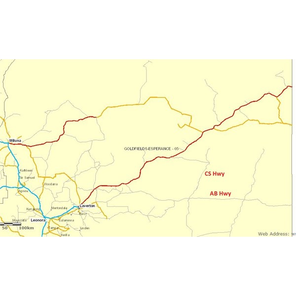
OK, that's interesting. So all the roads shown on that map, even the thin gray lines ("Access Roads"), are considered gazetted, right?
Is there a similar online resource for SA? :)
Going by the WA site, the AB is a gazetted road in WA.
As is the CS, though oddly it is not shown going all the way through to
Warburton. So for some reason, that section of it is not "gazetted"?
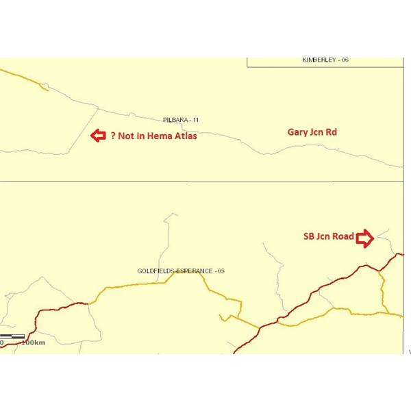
Likewise farther north...only the southern ~50 km of the Sandy Blight Jcn Road are gazetted. But the entire stretch of the
Gary Junction Road is.
BTW, that WA map also shows a road apparently between Punmu and Parnngurr that is not in the 2017 Hema Road & 4WD Atlas. But I suppose the Hema Map Patrol can't keep up with everything. :)

AB and CS

GJ and SBJ roads
FollowupID:
892539
Follow Up By: Candace S. - Tuesday, Jul 17, 2018 at 01:49
Tuesday, Jul 17, 2018 at 01:49
OK, I did find a map viewer for SA:
SA Map Viewer
But it also has this disclaimer on it:

Disclaimer
Nevertheless, I pulled up the "state maintained roads", and not surprisingly the AB past
Mabel Creek is not among them.
The site offers the option to download a .kmz file, which I should be able to open with Google Earth. I presume it shows a lot of roads, because the file is some 750 MB in size! Perhaps that could be considered an official map of gazetted roads. :) Unfortunately, every time I try to open that giant file, Google Earth crashes.
FollowupID:
892559
Follow Up By: The Explorer - Tuesday, Jul 17, 2018 at 13:28
Tuesday, Jul 17, 2018 at 13:28
Hi
Not sure what file you downloaded but the "state maintained roads" kmz file is only ~8mb and opens easily in Google Earth. Click on the picture below to download it.

SA "state maintained roads" kmz file
Cheers
Greg
| I sent one final shout after him to stick to the track, to which he replied “All right,” That was the last ever seen of Gibson - E Giles 23 April 1874 Lifetime Member
My Profile My Blog Send Message
Moderator |
FollowupID:
892563
Follow Up By: Candace S. - Wednesday, Jul 18, 2018 at 00:24
Wednesday, Jul 18, 2018 at 00:24
Thanks, Greg.
In SA are "state-maintained roads" = "gazetted roads" ?
I got the huge KMZ file when I downloaded this: "Navigable roads, including public and private access roads and tracks."
I can look at that data set on their viewer. In which case the whole AB and a lot of the little side tracks (such as those in the Emu area) show up. But back to the original question: if it shows up on this map viewer, is it a "gazetted road"?
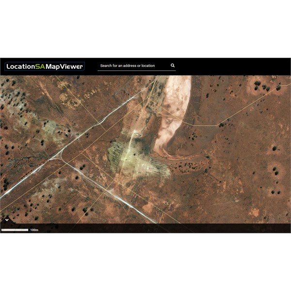
BTW, when you zoom way in on their viewer, the roads as traced in the data set are significantly off when compared to the satellite photo:

Location SA Viewer - south end of Emu Claypan
FollowupID:
892583
Follow Up By: The Explorer - Wednesday, Jul 18, 2018 at 14:55
Wednesday, Jul 18, 2018 at 14:55
Sorry I thought you were just referring to "state maintained roads" so that is all I donwloaded. Haven't bothered with any other data. I have no idea if "state maintained roads" = "gazetted roads".
Displacement from underlying sat/airphotos is not totally unusual (sat/air photo generally out a bit) but what is shown in the screen grab you have taken suggests major inaccuracy somewhere - could be a consequence of overlying data being filtered to reduce size and speed up load time or something. May just be designed to be looked at from a lower zoom level.
Cheers
Greg
| I sent one final shout after him to stick to the track, to which he replied “All right,” That was the last ever seen of Gibson - E Giles 23 April 1874 Lifetime Member
My Profile My Blog Send Message
Moderator |
FollowupID:
892599
Reply By: Ron N - Saturday, Jul 14, 2018 at 19:48
Saturday, Jul 14, 2018 at 19:48
I can't speak for other States, because each State has different legislation, regulations, and other ordinances, covering their definitions of "roads."
However, the link below contains the definitive description of what constitutes a "road" in W.A.
It is a veritable minefield, the description of a "public" or "gazetted" road.
Remember that roads can be surveyed and gazetted - but they can also be closed - whereby the road closure is also published in the Govt Gazette.
Gazetted roads can be closed via an application from an adjacent landowner, or a Shire council, due to a number of reasons - the most common being a lack of use, by a road re-alignment, or by the landowner wanting to limit unnecessary movement through his/her property/properties, via a redundant thoroughfare.
W.A. State Land brochure - creation of a road. (PDF file download)
Be aware that when the W.A. State Govt finally makes a settlement with the Noongar Boodja Trust (expected to be early 2019), all Unallocated Crown Land and unmanaged
Reserves in the S.W. of W.A., will then become Aboriginal (Noongar) Lands.
I have little doubt that Aboriginal Lands permits will then be required for whites to access these areas.
Cheers, Ron.
AnswerID:
620161
Follow Up By: The Explorer - Saturday, Jul 14, 2018 at 20:13
Saturday, Jul 14, 2018 at 20:13
"permits will then be required for whites to access these areas."
I think you mean those that are not the traditional owners are likely to require a permit - the colour of you skin would not be the determining factor. Not all non-traditional owners are "whites".
Cheers
Greg
| I sent one final shout after him to stick to the track, to which he replied “All right,” That was the last ever seen of Gibson - E Giles 23 April 1874 Lifetime Member
My Profile My Blog Send Message
Moderator |
FollowupID:
892510
Reply By: GarryR - Sunday, Jul 15, 2018 at 06:42
Sunday, Jul 15, 2018 at 06:42
I have encountered these problems of what is a gazzetted road. Some prob[em lays when the land goes from freehold to leasehold, and then all tracks within this/these properties become private tracks. I have in the past and still do, ring these properties for access stating my purpose and the route I wish to take. In most cases permission is granted, and alternative directions may be given due to stock movements etc. I recently travelled on private tracks with permission and was thanked for doing the right thing by asking first. I stated an approx date, and was given the station frequency to monitor once on the two properties. This station has done this due to an accident when and unauthorised vechile entered the property and had a head on with one of the staff on a motorbike going over a crest. Some station ownesr are now beginning to get these tracks deleted off the maps all together which will make things even harder to travel, or are letting these tracks be over grown and making new tracks that don't show on a map leading you to where ever (a serious risk to take if you do not know where it ends).
AnswerID:
620163
Follow Up By: The Explorer - Sunday, Jul 15, 2018 at 11:08
Sunday, Jul 15, 2018 at 11:08
You can't get a track deleted off Google Earth (and other satellite/air image
services)...which is always a good reference in some area.
| I sent one final shout after him to stick to the track, to which he replied “All right,” That was the last ever seen of Gibson - E Giles 23 April 1874 Lifetime Member
My Profile My Blog Send Message
Moderator |
FollowupID:
892514
Follow Up By: Bob Y. - Qld - Sunday, Jul 15, 2018 at 16:38
Sunday, Jul 15, 2018 at 16:38
Some years back, when I was still managing a station on the Diamantina, we had a couple in a Hema Nissan wagon rock up, obviously a bit bushed, even with all their u-beaut GPS gadgetry.
They'd turned off the
Winton-
Boulia bitumen, intending I believe, to drive through an old gazetted road to Springvale station. We maintained the first 25 odd kms ourselves, for easy access for incoming double decker road trains, so was very
well used and they followed this through to the
homestead, about another 90 kms. Why they, or their gadgetry, didn't keep them going onto Springvale I don't know, but it would have been an arduous task, as sections of the track were rarely graded.
In course of conversation, I asked if they could remove this track from their maps, which they appear to have done. It is still marked in the Topo map though, in the Hema 4WD Map set.
And for history buffs, this gazetted road was, I believe, part of the planned railway alignment from
Winton to Springvale Station. Construction of the line only ventured west of
Winton for about 50 Kms, before I think WWI intervened, and it was never completed.
Bob
FollowupID:
892519
Follow Up By: Member - ACD 1 - Sunday, Jul 15, 2018 at 19:31
Sunday, Jul 15, 2018 at 19:31
A major source of error/confusion/angst/anger/conflict is the use of satellite imagery in the use of creating the maps.
Satellite images of the area around our property have been used to create publicly available maps and all of our "farm tracks" have been included and highlight as roads on digital versions. They have even named the main driveway into the farm after the <100 metres of gazetted road that ceases before our main
gate.
We are constantly encountering trespassers (because we have signed it as "no public access/private property")
camping by our lake (which is actually a dam we created from a natural depression) and exploring the
ruins and taking souvenirs from the old homesteads.
Anyone who farms can appreciate the damage, legal liability, risk to property and stock (especially when calving and lambing) of having trespassers on your property. We have had mills/tanks damaged, fires started, stock injured and off course the shit and rubbish left behind as a "thank you" for allowing them to trespass.
Try to explain that it is private property - you are met with verbal abuse, threats of violence etc etc. Those who are polite and apologetic for their mistake are offered the option to move on the next morning. However, these types are few and far between now.
We have tried to have the errors fixed, roads removed - but you simply can't.
Our solution after years of frustration - we exercise our right as landholders to legally remove vermin from our property. It's amazing how a spot light in the distance and the retort of a high powered rifle dispatching foxes encourage people to move on.
Cheers
Anthony
FollowupID:
892530