Trip Report - Balgo to Kiwirrkurra Track

Submitted: Monday, Jul 02, 2018 at 22:25
ThreadID: 136928 Views:4600 Replies:4 FollowUps:2
This Thread has been Archived
Hi all.

We’ve just returned to Perth winter after a short three weeker to the north; which included the Balgo to Kiwirrkurra track.

As this is a remote area option which isn’t traveled too much, other than by community members, I thought I’d pass on some notes.

Diesel at Balgo is now 24/7 via a credit card set-up. Very efficient. Just remember (because it wasn’t on the pumps) that diesel is pump #1. Was $2.34/L and, at Kiwirrkurra (normal long lunch till 1400 hours) it was $2.40 (or something close. (not bad at all, these prices, given the remoteness). The Balgo store is amazing and open 7 days. The K store is also well provisioned and well worth supporting.

For any of youse who might think of doing this trip. Don’t miss the lookout over ‘Balgo Pound’ immediately south of the Balgo watertank via a very short off-leg. Simply amazing. There are also fantastic views 10 or so kays further south.Lake MacKay is expansive and you get great views, plus a Desert Oak grove. Scenically, that’s about it. The rest of the track is easy dunes and the usual spinifex scrublands.

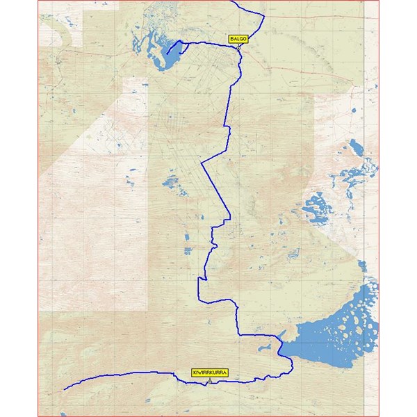
The total distance is close to 500 kays and includes a huge ‘loop’ to the east to Lake MacKay shores. See image.

The first 100 kays south of Balgo is easy via a graded track kept open by a an exploration mob basing itself at Yagga Yagga.

The last 100 kays to Kiwirrkurra is even zippier via a very recently graded ‘road’ courtesy of another exploration outfit.

The middle 300 kays is slow and scratchy in places, but is very easy to follow, and is kept open by community travel between B and K. (we met one such vehicle just north of the Lake).

There is good easily gettable water in the ground level tank at Bibbard. (you could feed the resident ‘fairly’ friendly dingo some spare provisions).

The only difficulty in the entire length of the track was a small gully crossing some (I think) 15 or so kays south of Bibbard. The line that was being taken was with the wheels high up on the steep wall of the gully on one side with the other side wheels on the flat. We didn’t like it much and opted to create a new line but it was extremely tight. To be honest, it still leaves me feeling a bit ill as to what might have happened if it got pear shaped.

Anyway, it worked for us and here we are…

Cheers.

JB.
Back Expand Un-Read 5 Moderator

Reply By: oldfart1953 - Tuesday, Jul 03, 2018 at 08:36

Tuesday, Jul 03, 2018 at 08:36
Hi John,
Thanks for this, it brings back a lot of wonderful memories I have of that area.
A few years ago I had the privilege of living and working in Balgo, regularly visiting Mullen and Billiluna.
This area is truely a jewel in the crown of The Tanami.
AnswerID: 619922

Reply By: ExplorOz Team - Michelle - Tuesday, Jul 03, 2018 at 14:33

Tuesday, Jul 03, 2018 at 14:33
Hi John and welcome back to Perth's charming winter ;) and thanks for posting your update - very interesting. May I draw your attention to the place names listed in your post that do/don't have hyperlinks. Place names without a link indicate the Place record page doesn't yet have any photos added so as there are a few here that meet that criteria (eg. Balgo) I wondered if perhaps you could please go to Places, and look up that Place and then add any photos you might happen to have taken. Understand you've probably only just back, so when you get a chance. Also write up some comments for the places you passed through or visited.
Michelle Martin
Marketing & Customer Support
I.T. Beyond Pty Ltd / ExplorOz

Lifetime Member
My Profile  My Blog  Send Message
Moderator

AnswerID: 619927

Reply By: ian - Wednesday, Jul 04, 2018 at 00:06

Wednesday, Jul 04, 2018 at 00:06
Thanks John.
very interesting.
Ian
AnswerID: 619935

Reply By: colanjen - Thursday, Jul 05, 2018 at 11:23

Thursday, Jul 05, 2018 at 11:23
Thanks for posting that, my maps indicate some of that track is private and also on Aboriginal land. What was the go re permits?
Also could you give me a rough time frame it took you in days.

Regards Col.
AnswerID: 619957

Follow Up By: John Baas - Thursday, Jul 05, 2018 at 12:22

Thursday, Jul 05, 2018 at 12:22
Hi Col.

All that land is Aboriginal owned and requires a permit.

Just go to the usual DIA website online permits and tick the Balgo and Gary Junction Hwy options and in the comments tell them that you wish to transit between Balgo and Kiwirrkurra. I also added that we carried recovery gear, satphone, HF etc.

Got a e-permit back by email in two days.

If you want to go to Lake Gregory as well, you can get permits at the Mulan store, or get them online from one of the Mulan, Paraku websites.

We camped out one night. Started at about 1100 the first day and hit Kiwirrkurra 1400 the next.

Cheers.

John.
2
FollowupID: 892280

Follow Up By: John Baas - Monday, Jul 09, 2018 at 20:26

Monday, Jul 09, 2018 at 20:26
My apologies. Silly error. Was camped for two nights out on the track.

So... just over two days travel time.

Cheers.

John.
1
FollowupID: 892384

Sponsored Links